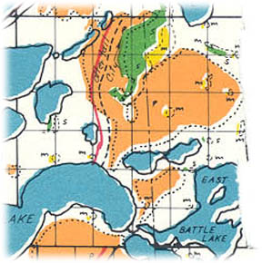
 From Trygg Historical Maps, Trygg Land Office, Ely, MN www.trygglandoffice.com/maps.html b=bottom land, m=marsh, p=prairie, s=swamp |
Basic Facts: Township 133N, Range 39W |
|
|
Welcome to Otter Tail County Minnesota |
|
Girard Township |
|
|
POPULATION |
|
|
|
From Trygg Historical Maps, Trygg Land Office, Ely, MN www.trygglandoffice.com/maps.html b=bottom land, m=marsh, p=prairie, s=swamp |
Basic Facts: Township 133N, Range 39W |
|
[Copied by Lory Brasel, lbrasel@leagent.net, from the book "History of Otter Tail County" Volume I - 1916 by John W. Mason]
Girard township was created by the county commissioners on March 21, 1882 iin response to a petition signed by D. W. Wolcott and others, praying that township 133,range 39, be organized under the above name. The twenty-five legal voters of Girard township who signed the petition asking for the organization of the township were as follow D. W. Wolcott, J. C. Howard, R. Oaks, Sr., Jesse Burdick, A. W. Whiting, J. L. Whiting, A. Whiting, D. I. Newman, E. B. Anderson, R. B. Anderson, R. Oaks, Jr., James W. Anderson, W. W. Anderson, M. M. Anderson, J. L. Boyd, George W. Werner, Nels Werner, F. D. Ayers, Simon McAteer, Wallace Johnson, Thomas L. Mason and George Fort. This county was ushered in on the same day with Edna and Paddock township and in the order of organization it ranks fifty-fifth. It is bounded on the north by Otter Tail, on the west by Everts, on the south by Nidaros and on the east by Henning. This is truly a township of lakes.
There are twelve lakes lying wholly or partly within this township which have an acreage of approximately seven thousand acres, or almost one-third of the entire township. West Battle lake is the largest with East Battle lake a close second. Lakes Blanche, Mason, Tamarack, Emma, Ethel, Beauty Shore, Annie Battle, Park, Gourd and Hanson follow in the order of their size. The lakes of this township present a more striking appearance than some of those in other sections of the county and especially some of those townships which can boast a greater number. This is due to their size and beautiful surroundings, which can hardly be excelled in any other section. This township has never had a railroad within its limits and it is safe to predict that it never will. This is due, however, to the location of the lakes which almost surround the township. The Wadena and Fergus Falls branch of the Northern Pacific should have been run through this township in order to give it the shortest line, but it was impossible to build a road around the lakes. The great extension of the lakes also makes it very hard to lay out roads and the farmers living within this township have to travel many unnecessary miles to get their products to market. In East Battle lake there are two islands of one hundred and seventy-five and sixty two acres, respectively. The present township officers are as follow: Supervisors, George Huggett, Ray Kimber and R.W. Reed; clerk, W. T. Perry; treasurer, Gust Hanson; assessor, Hjalmer Magenson; justice, Lester Whiting; constable, F. Kimber.
There are three platted towns in this township. They are all located on the shores of different lakes as follow:
Stuart Lake Park was platted by Martin Aalberg for A. L. Murdock and recorded in the office of the register of deeds, July 25, 1902. It is located on the shores of Stuart lake and West Battle lake in Girard township.
Beauty Shore is located in Girard township on the shore of Beauty Shore lake. It was platted by O. G. Molden for Peter and Christiana Hansen (his wife) and recorded in the office of the register of deeds, January 4, 1911.
Woodland was platted by Martin Aalberg for H. O. and Anne Moe (his wife) and recorded in the office of the register of deeds August 1, 1913. It is located on the shore of West Battle lake in Girard township.
Population totals in state and federal census summaries.
| Girard | |
| 1870 | |
| 1875 | |
| 1880 | |
| 1885 | 219 |
| 1890 | 193 |
| 1895 | 250 |
| 1900 | 263 |
| 1905 | 303 |
| 1910 | 250 |
| 1920 | 339 |
| 1930 | 318 |
| 1940 | 414 |
Places of birth for Girard Township in the 1905 state census.
| Native (USA) | 112 | 37% |
| Minnesota | 152 | 50% |
| Foreign | 38 | 13% |
| Germany | 7 | 18% |
| Sweden | 7 | 18% |
| Norway | 15 | 39% |
| Canada | 2 | 5% |
| Ireland | 1 | 3% |
| Denmark | 2 | 5% |
| England | 3 | 8% |
| Poland | 0 | 0% |
| Finland | 1 | 3% |
| Russia | 0 | 0% |
| Scotland | 0 | 0% |
| Other | 0 | 0% |
Names
The following names have been extracted from original land records (by John Nelson)
and Mason's History (by Karen Terry). Aalberg
, Martin
; Allen
, James H
; Anderson
, Buckley B
, EB
, Edwin B
, Henry M
, James W
, Jedediah R
, MM
, Myron M
, RB
, Richard B
, William W
, WW
; Ayers
, FD
; Benson
, Arthur W
; Borden
, Spencer
; Bowker
, Arthur G
; Boyd
, Jacob L
, JL
; Burdick
, Jesse
; Cook
, Charles E
; Douglass
, Andrew E
; Fort
, George
; French
, Charles H
; Hammer
, George
; Hansen
, Christiana
, Peter
; Hanson
, Gust
; Hatch
, Mary S
; Howard
, JC
; Huggett
, George
; Johnson
, Wallace
; Kimber
, Ray
; Kinber
, F
; Magenson
, Hjalmer
; Mason
, Thomas L
; Mcateer
, Simon
; Moe
, Anne
, HO
; Molden
, OG
; Murdock
, AL
; Newman
, David I
, DI
; Nichols
, Burnett
; Oaks
, R Jr
, R Sr
, Reuben
; Ochsner
, Tobias
; Palmer
, John
; Perry
, WT
; Reed
, RW
; Thompson
, Reese W
; Trowbridge
, Albert H
; Vick
, Felix F
; Werner
, George W
, Nels
; Whiting
, A
, Almon
, Arthur W
, AW
, Francis L
, JL
, Lester
; Wolcott
, David W
, DW